

 Thanks: 0
 Likes: 54
 Needs Pictures: 0
 Picture(s) thanks: 0
Results 31 to 45 of 78
Thread: Imperial vs Metric system
-
23rd November 2013, 06:32 PM #31
 Mechanical Butcher


- Join Date
- Oct 2004
- Location
- Southern Highlands NSW
- Posts
- 911
 Funny, even a simpleton can understand metric.
 Originally Posted by toolman49

The USA is slowly coming around to metric. Cars and motorbikes made there have been metric since the '90s.
Imperial was good enough to get them to the moon though.
It'll be a sad day for us enthusiasts of old machinery, if inch sized fasteners etc are no longer mass produced.
Jordan
-
23rd November 2013, 06:53 PM #32
GOLD MEMBER
- Join Date
- Jul 2010
- Location
- Melbourne
- Posts
- 7,770
I'm in a quandary, I've discovered a paradox which may well lead to the break down of my measuring system.
I'm roughly 1.8 stus tall........ how can that be?
Stuart
-
23rd November 2013, 07:04 PM #33
GOLD MEMBER
- Join Date
- Jan 2011
- Location
- Far West Wimmera
- Age
- 64
- Posts
- 2,674
So does an American Micrometer have only fractions on it? I have seen verniers like this. Originally Posted by _fly_
Dean
-
23rd November 2013, 08:34 PM #34
GOLD MEMBER
- Join Date
- Jun 2008
- Location
- Victoria, Australia
- Age
- 74
- Posts
- 6,057
I like metric, but having grown up with both, I tend to "think" in imperial I think milk still comes in pints and miles per gallon still means something more than liters per 100 kilometers... I'd grab a 1/4" drill rather than a 6mm drill.
I like this video... non believers can start watching from 8:42
Slightly further off topic, but hands up if you remember this.... they flogged the song endlessly on our local radio...
Regards
Ray
-
23rd November 2013, 08:55 PM #35
Senior Member
- Join Date
- Mar 2009
- Location
- Brisbane
- Posts
- 341
Hi Originally Posted by Bedford
Does that white tape have a brand name?
-
23rd November 2013, 09:09 PM #36
The Master's Apprentice
- Join Date
- Dec 2008
- Location
- Yarra Valley Vic oz
- Posts
- 2,566
I'm not sure as it's not mine.
-
23rd November 2013, 09:19 PM #37
Senior Member
- Join Date
- Sep 2008
- Location
- Riddells Creek
- Posts
- 299
What's a radius tape? Originally Posted by _fly_
-
23rd November 2013, 10:16 PM #38
GOLD MEMBER
- Join Date
- Jan 2011
- Location
- Far West Wimmera
- Age
- 64
- Posts
- 2,674
Wrap it around a circumference and it will give you the radius of the circle with vernier accuracy. Keith Fenner uses them a bit. Originally Posted by Techo1
Dean
-
23rd November 2013, 10:21 PM #39
Blacksmith, Cabinetmaker, Machinist, Messmaker
- Join Date
- Dec 2011
- Location
- Canberra
- Age
- 40
- Posts
- 4,432
1915 17"x50" LeBlond heavy duty Lathe, 24" Queen city shaper, 1970's G Vernier FV.3.TO Universal Mill, 1958 Blohm HFS 6 surface grinder, 1942 Rivett 715 Lathe, 14"x40" Antrac Lathe, Startrite H225 Bandsaw, 1949 Hercus Camelback Drill press, 1947 Holbrook C10 Lathe.
-
23rd November 2013, 10:31 PM #40
GOLD MEMBER
- Join Date
- Aug 2010
- Location
- ACT
- Age
- 85
- Posts
- 1,969
Does it have 12 inches to the foot? If it has 10 it could be in Cape feet as it has 10 inches and although the foot is not the imperial foot the conversion goes to about 5 decimals. Originally Posted by Bedford
RegardsHugh
Enough is enough, more than enough is too much.
-
23rd November 2013, 10:41 PM #41
Senior Member
- Join Date
- Feb 2013
- Location
- Laidley, SE Qld
- Posts
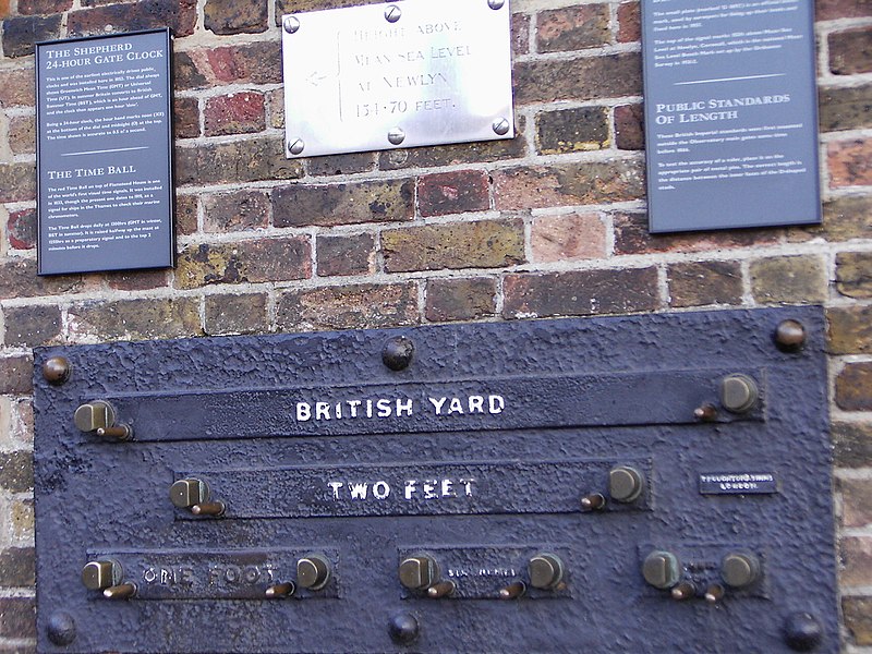
- 368
Ye olde length gauges at Greenwich Observatory
-
24th November 2013, 01:40 AM #42
GOLD MEMBER
- Join Date
- Jan 2005
- Location
- Adelaide
- Age
- 65
- Posts
- 697
Originally Posted by snowyskiesau
They don't seem to put as much emphasis on teaching any tables as I would like them to these days. The teachers seem to pretty much leave it up to the parents to teach the kids tables. When I went to school, every morning started with tables.
We went to Decimal Currency in 1966. That in its self was right up there with the imperial system if you think about it. The 14th of February 1966. Niether the start nor end of the financial year or the calander year. Not Australia day... Valentines day!!!... Go Figure.
We actualy went to the metric measuring system in the 70's, some 10 years after decimal currency. I think it was about 1976, but I don't remember the actual date.
You have to admire the simplicity of the metric system, & the way it flows across the board. EG., A Lt of water weighs 1kg.
The US Military use metric for distance, but they still seem to use pounds for weight.
And I must admit, that MPG had a lot more meaning to me than Lt/100 for a long time, but these days I tend to talk in Lt/100.
Does anyone know the standard length of a White line marking the centre of the road? It used to be 12 feet.
SteveThe fact remains, that 97% of all statistics are made up, yet 87% of the population think they are real.
-
24th November 2013, 05:12 AM #43
Banned
- Join Date
- Jul 2013
- Location
- Perth
- Posts
- 628
Knots
Knots R still used for navigation at sea because they match the circular compass 360 degrees (1 nautical mile = 1/60th of a degree).
The problems with distances... on charts is that you can ONLY use the Lattitude (distance N or S from the equator) or the side scale on the chart for plotting your distance... because longitudinal distances converge toward the poles.
TVMDC [True Virgins Make Dull Companions] or more correctly True, Variation, Magnetic, Deviation, Course, 'to steer' (The mariners aid memoir) being how one converts magnetic (compass) bearings to true for chart use or vice versa.
This base 12 calculation stuff seems to give "the wee kiddies" (those born after the 70's) all sorts of gypper at the navigation classes - they are fine as long as the GPS works - but seemingly screwed when it doesn't!.
Wasn't it only yesterday some pilot and navigator landed their dream lifter jumbo jet at a small municipal airport 13 km's away from their correct landing strip?
GPS error.... cough cough...
Funny but when I bought my 1st GPS the packaging clearly said words to the effect "only to be used for secondary navigation" (i.e. as a backup to manual nav) and never to be used as a primary source of navigation) yet today we have car GPS navigators etc and EVERYONE just trusts them.
Thankfully the yanks quit dithering the GPS signals some years back... increasing accuracy somewhat.
That said in Gulf War 1 - I was offshore when the first strike started..... went out and followed a GPS track.... but when we tried to follow it back.. the war had commenced and the seppos screwed with their GPS satellites data - had we followed our GPS (and not the compass) wed have run out of fuel somewhere near antarctica.
Then I was myself undergoing nav training on the day after 9/11 and happened to have my hand held GPS with me in Perth at the nav school.
I had been fishing approx 600 km's south of Perth and saved waypoints of some honey holes - as well as up at shark bay and saved waypoints.
On 9/12/2001 - when I entered a 'go to' on the GPS for the way points south of Perth - it pointed me NORTH, and when I entered "go to" for the way points north of Perth at Shark Bay it told me to go south, (it had a built in electronic fluxgate compass which seemed to go nutso).
For ME - GPS will always remain a backup form of navigation.
On trips offshore to places like the Houtman Abrolhos Islands (54Nm out of Geraldton) while I have and use a GPS chart plotter - I still carry paper charts with courses and back bearings all plotted manually - before leaving. The vessel has a chart table and chart lights, chart tube and carry's parallel rules, dividers & a pad and Russian space biros just in case. The compass is even aligned every 3 years by a compass aligner to give me my deviation tables. Might not need it often but the day I do its all there along with the knowledge of how to use it.
I consider those of us born in the imperial age who have converted to metric to have an advantage of those younger with only experience of one system of measurement.
These blokes seemed to have managed alright without metrics or a GPS Chart plotter...
I'd like to become conversant next with a sextant just for the heck of it!.
My Tuppence.
-
24th November 2013, 06:07 AM #44
Senior Member
- Join Date
- Dec 2010
- Location
- Syd
- Posts
- 231
In more naive times, before radio was populated with angry little men - probably the early 70s during the introduction - a bloke who used to feature a sparrow on his morning show, did pull that stunt....and remarkably effectively, lots of red faces that day. Originally Posted by _fly_
I'd wager, the exact opposite, visual approach, target fixation and disregard to any instrumentation. There were cases here of large jets lining up with under construction runways in the NDB/VOR era and probably before that using radio range. Originally Posted by Timless Timber
Last year or the year before, a large US military transport did land at a small GA airport adjacent to the military base with similar runway alignments, pity for them, a senior general was on board.
-
24th November 2013, 06:52 AM #45
The Master's Apprentice
- Join Date
- Dec 2008
- Location
- Yarra Valley Vic oz
- Posts
- 2,566
The tape is at my dads, I'll try to get hold of it during the week and get some more info. Originally Posted by A Duke
I'm pretty confident it's just a dud from China though.


